|
||

|

|
|

|
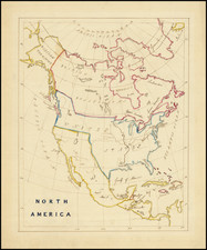
John Mitchell's A Map of the British and French Dominions in North America . . . is widely regarded as the single most important map of North America published during the 18th Century. At the most comprehensive map of North America produced prior to the French & Indian War, the map graphically illustrates the various territorial claims made by the competing British and French empires and also the various British colonies.
John Mitchell (1711-1768), a respected British physician, botanist, chemist, biologist, and surveyor, lived for a time in Virginia, but returned to England in 1746, where h remained there until his death. Mitchell initially conceived of his map of North America in order to present to the British public a single large format image of all the colonies, in order to illustrate the extent of the French threat to the British claims in North America. Mitchell completed his first draft in 1750. However, because Mitchell was limited to publicly available sources of information, this initial effort was rather crude, even in Mitchell's own opinion. As word of Mitchell's work spread, The Board of Trade and Plantations retained Mitchell to make a new map using the official maps and reports in the Board's possession. The Board also instructed all the colonial governors to send detailed maps and boundary information for Mitchell's use.
Mitchell's map was first published by Andrew Millar in 1755, the year before war broke out with the French. The map is decidedly pro-English in its interpretation of the various boundaries and geographical information depicted on the map, as would be expected for what amounted to thinly veiled pre-war propaganda. In addition to the geographical detail shown on the map, Mitchell included many annotations describing the extent of British and French settlements. He also submitted a report to the Board in 1752, listing the French encroachments and his ideas to encourage British settlement west of the Appalachian Mountains, as a means of combating French influence in the region. Mitchell is also likely wrote The Contest in America Between Great Britain and France by an Impartial Hand (1756), which addresses the same topic.
The first edition of the map was quickly followed by a second edition in 1757 (the present example), which Rumsey believes to be the rarest of all editions of the map and certainly the most comprehensive representation of Mitchell's work, being the first edition to include two large blocks of text in the Atlantic Ocean, which provides Mitchell's data sources and an account of how he compiled the numerous provincial maps to create this map. After Mitchell's death in 1768, the plates were purchased by Jefferys & Faden, who revised the map and issued a third edition in 1773-74. Faden published a fourth edition in 1775, with the title changed to A Map of the British Colonies in North America ....
Mitchell's map shows the British Colonial claims of Virginia, both Carolinas, and Georgia extending beyond the Mississippi to the Pacific Ocean. In the West, Mitchell's treatment of the lower Missouri is a vast improvement over earlier maps. Regarding the source of the Missouri, Mitchell notes "Missouri river is reckoned to run westward to the Mountains of New Mexico, as far as the Ohio does eastward," reflecting his belief in symmetrical geography. Mitchell correctly shows the northern branch of the Missouri to be the main branch of the river, although his estimate of the latitude of the river's source is inaccurate. Nonetheless, the information Mitchell's map provided led Meriwether Lewis up the Marias River to determine the northern reaches of the Missouri River basin.
Mitchell's map was the only map used during the Treaty of Paris peace negotiations between Great Britain and her former American colonies in 1783 and has been utilized to resolve many subsequent treaty negotiations and boundary disputes, the latest in 1932. Thomas Jefferson recommended that Nicholas King use Mitchell's map in preparing a new map for Meriwether Lewis, saying: "it was made with great care we know from what is laid down in those western parts with which we have lately become acquainted."
A good example of the most important printed map in American history.
![(Texas Land Title - Spanish Province of Texas and New Philippines) [East Texas Borderlands Spanish manuscript land title issued under the Spanish Governor Manuel de Salcedo on the Eve of the Gutiérrez-Magee Filibustering Expedition]](https://storage.googleapis.com/raremaps/img/small/88919.jpg)
![[ Hungarian Traveler In the California and the West with a Comanche and Wichita to Hungarian vocabulary ] Levelei Éjszakamerikából -- Tizenkét eredeti rajzok után készült kő- és egynéhány fametszettel. Közli Prépost István (Letters from North America)](https://storage.googleapis.com/raremaps/img/small/98502.jpg)
![[First State of the Popple Key Sheet] A Map of the British Empire in America with the French and Spanish Settlements adjacent thereto by Hen. Popple.](https://storage.googleapis.com/raremaps/img/small/92714.jpg)