|
||

|

|
|

|
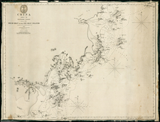
Scarce decorative map of China, Japan and Korea, along with neighboring regions, by Cantelli da Vignola and published in Rome by Rossi.
Fine early map of China, Korea and Japan, based on Martino Martini's map, prepared by Giacomo Cantelli da Vignola and engraved by Giorgio Widman for Rossi's Mercurio Geografico.
Formosa is shown as Loqucio o Formosa I. The name Taiuan o N. Zelanda also appears next to the island. Macao is shown, but pre-dating Hong Kong. The Great Wall of China is prominently depicted.
Korea is shown as a long narrow peninsula, with a number of cities named. Ezo is depicted as part of mainland Asia. Embellished with an superb baroque title cartouche surmounted by an Eastern potentate and flanked by brimming cornucopiæ and mermaids.
Giacomo Giovanni Rossi (1627-1691) was an Italian engraver and printer. He worked in Rome, the heir to an important printing business founded by his father, Giuseppe de Rossi (1570-1639). Giuseppe began the press in 1633 and Giovanni and his brother, Giandomenico (1619-1653) took it over upon his death. The brothers expanded the business and by the mid-seventeenth century it was the best-known printing house in Rome.
For his maps, Giovanni worked with Giacomo Cantelli da Vignola. They produced the Atlas Mercurio Geografico. The first edition is undated, but the second was issued in 1692, a year after Giovanni’s death. The maps were by Cantelli. The firm also published maps based on those of Nicolas Sanson.
Later, the business passed to Lorenzo Filippo (1682-?). By 1738, the firm was known as Calcografia Camerale, then, from 1870 to 1945, as the Regia Calcografica. Today, the firm is still in business and is called Calcografia Nazionale. It operates as a free museum and offers one of the best collections of prints and plates in the world.
![[Kyoto, Japan] Plan de la Ville de Meaco](https://storage.googleapis.com/raremaps/img/small/61134.jpg)
![[ Japan ] Royaume du Iapon. Designe par le Pere Ph. Briet de la Compagnie de Iesus . . .](https://storage.googleapis.com/raremaps/img/small/75238.jpg)
![Province de Chen-Si [Shaanxi Province]](https://storage.googleapis.com/raremaps/img/small/95545.jpg)
![[ Dalai Lama ] Grand Lama](https://storage.googleapis.com/raremaps/img/small/97873.jpg)