


|
||

|

|
|

|
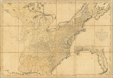
Interesting and detailed map of the US and Canada, extending nearly to the Rocky Mountains.
Texas is just now part of the United States. The map includes at least a dozen place names and shows the road from Natchtoches to the Presidio de Rio Grande. The west and old Northwest now include the states of Iowa and Wisconsin. Many Indian Tribes located west of the Mississippi. Massive Osage Territory above Texas. There are a number of early roads and forts located throughout the map.
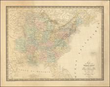
Andre Hubert Brué was a French geographer and cartographer. Born in Paris, he served in the French Navy, joining the Baudin expedition to the Pacific (1800-1804). After his sea service, Brué applied his navigation and charting skills to creating finely-crafted maps, which were renowned for their crisp engraving and accuracy. He drew directly on the copper of the plate, creating what he called encyprotypes. He is best known for the Atlas universal de géographie physique, politique, ancienne et moderne.
![Louisiana [Large-Paper Example]](https://storage.googleapis.com/raremaps/img/small/83278.jpg)
![[School Girl Map] United States by Betsey C. Converse](https://storage.googleapis.com/raremaps/img/small/66109.jpg)