![The Eagle Map of the United States Engraved For Rudiments of National Knowledge. 1833. [with:] Rudiments of National Knowledge, Presented To The Youth Of The United States, And To Enquiring Foreigners. By A Citizen Of Pennsylvania. By Joseph & James Churchman](https://storage.googleapis.com/raremaps/img/small/86933.jpg)


|
||

|

|
|

|
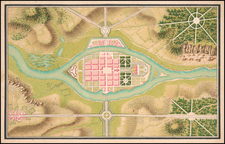
Remarkably rare map of the United States in the shape of an Eagle, from an extremely rare geography book, Rudiments of National Knowledge, Presented To The Youth Of The United States, And To Enquiring Foreigners. By A Citizen Of Pennsylvania." Published by E.L. Carey & A. Hart, Philadelphia, 1833.
The map represents America as an eagle; t he states are shown in outline color with the eagle transparently sitting atop the nation. The eagle's head coincides with New England (except Maine), its eye with Vermont, its neckline follows Lakes Ontario and Erie, and the wing outlines Lakes Huron and Superior (and further west the eventual Canadian-American border at the 49th parallel). The eagle's breast follows the Atlantic seaboard; its talons form Florida - though the claws protrude far from the coastline towards Cuba. The great inland empire of Louisiana is already being divided up into US states, with Louisiana and Missouri separated from the 'mainland' of the formerly French lands. The tail feathers are shaped to follow a border no longer in existence by 1848. The western borders of the subsequent independent and later US state of Texas are recognizable, as is the dividing line between the US and Mexico. The feathers follow the US inland border as it moves north, and disappears out of sight at the area disputed with Great Britain. The map also includes state boundaries, major cities, and hydrological features.
As noted by David Rumsey, "the 'eagle' map is most extraordinary and rare: it shows an eagle superimposed in engraving and color on the United States, with the Talons in Florida, the eye in Vermont, and the wings spreading west to the Missouri Territory. It is beautifully done."
It is believed that Joseph Churchman authored the text and his brother, James Churchman, authored the map. The engraving was done by Isaac W. Moore. The present example was formerly in the collection of noted American map collector Eric Wolf.
While Churchman's book can be found in a number of institutional collections, the book and map rarely appear on the antiquarian market. This example (acquired and sold in January 2008) was the first we have seen on the market since the map was offered by Robert Ross & Company in the late 1990s.
As of footnote, we have been advised that Joseph Churchman did not have a brother by the name of James Churchman and this reference (repeated in Phillips Maps), may be in error.
The complete text can be found at: babel.hathitrust.org/cgi/pt?id=loc.ark:/13960/t04x5nr8t
![[Charles Lindbergh] Lindbergh Spirit of St. Louis](https://storage.googleapis.com/raremaps/img/small/67114.jpg)
![[ Sea Monsters ] Meerwunder und Seltzame Thier / Wie Die In Den Nitnaecßtigen Laendern im Meer und auf dem Landt gefanden werden](https://storage.googleapis.com/raremaps/img/small/93252.jpg)
![(Florida Aviation - Early Photographs) [Original photograph album of Carlstrom Field, Florida, early Army Air Service Training Camp]](https://storage.googleapis.com/raremaps/img/small/84163.jpg)
![[Whoever is silent is Complicit -- Anti-Vietnam / Anti-American Poster] Vietnam: Sterminio | chi tace è complice](https://storage.googleapis.com/raremaps/img/small/89365.jpg)