


|
||

|

|
|

|
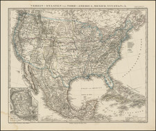
Interesting map of the United States and the end of the Civil War, featuring a number of strange western territorial boundaries. Nevada is an elongated rectangle which includes Pyramid and Mono Lake and everything east of the crest of the Sierras. Idaho includes all of modern Wyoming. Nebrasak Territory is shown running to Canada, although Dakota Territory is also shown. Arizona is also badly misprojected and Utah's Western border is far too the west of its final location. A number of western Forts and Camps are shown, including "Camp Floyd" near Salt Lake City and other unusual place names. The Cajon pass in So. California is shown, along with a volcano in Imperial Co. Lots of Indian Tribes & railroad info. I nice mix of accuracy & inaccuracy.
![(French & Indian War) The New Map of the British Dominions in North America; with the Limits of the Government annexed thereto by the late Treaty of Peace, and settled by Proclamation October 7th, 1763 [in:] The Annual Register, or a View of the History, Politicks, and Literature, for the Year 1763. Volume 6](https://storage.googleapis.com/raremaps/img/small/77573.jpg)

![[ Massive Misplace Idaho Territory ] The United States of North America.](https://storage.googleapis.com/raremaps/img/small/99361.jpg)