


|
||

|

|
|

|
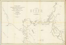
Interesting linen backed example of Ringgold's general map of the San Francisco Bay, extending up river to the Cities of Sacramento, San Joaquin and Stanislaus.
The map also shows town plans for Stockton, Suison City, Martinez, New York, Vallejo (with a note indicating that Vallejo was then the Capital of the State), Boston and Benicia. The most remarkable element of the map is the remarkable detail shown along the rivers, which include names for a number of islands and regions which had probably never before appeared on commercial maps (and in some cases, never again). The map includes soundings in the bays and rivers, points, and a host of other details, The Webster or Russian Embarcadero is shown, as is Sutterville, Washington, Indian Villages, Doaks Ferry, Martins, Mount Diablo and many smaller islands and other features.
Cadwalader Ringgold was a US Navy officer who served in the US Exploring Expedition and later headed an expedtion to the Northwest, before retiring briefly before the Civil War. Ringgold entered the US Navy in 1819 and commanded the schoone Weazel against West Indian pirates in the late 1820s. From 1838 to 1842, he participated in the Wilkes Expedition, In August 1841, Ringgold let a 60-man exploring party in San Francisco Bay, exploring the sources of the Bay for 20 days. This expedition travelled as far as Colusa, California.
In July 1849, Ringgold returned to San Francisco as commander of an official survey team surveying the harbor, shortly after the announcement of the discovery of gold in California.
Ringgold's next exepdition, the North Pacific Exploring and Surveying Expedition, ended prematurely for Ringgold when he contracted Malaria. The expedition was met in China by a separate expedition under the command of Commodore Perry, who convened an official panel, which determined that Ringgold was "insane" and relieved him of his command.
Ringgold's charts from his San Francisco Bay Surveys were published in A Series of charts, with sailing directions, embracing surveys of the Farallones, entrance to the Bay of San Francisco ... State of California, beginning with the 3rd edition in 1852. The work has the distinction of being the first set of published charts focusing on California and is an essential work for California collectors.
![(Western Photographs) [Collection of 35 Albumen Photographs by Isaiah Taber, Norman Reed, W.H. Jackson and others: California, Arizona, New Mexico, Colorado]](https://storage.googleapis.com/raremaps/img/small/90506.jpg)
![[ Baja California / Mexico ] Carta particolare della parte ocidentale della nuova Spagnia, e del la California . . . D'America Carta XXXI](https://storage.googleapis.com/raremaps/img/small/101394.jpg)
![[California] Honor Roll Foresters of America May 1, 1947 to May 1, 1948](https://storage.googleapis.com/raremaps/img/small/63016.jpg)