


|
||

|

|
|

|
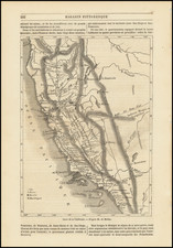
Nice example of Kino's seminal map of California, the map credited with ending the myth of California as an Island. Offered here bound into Volume 1 of Joseph Stocklein's Neue Welt Blott, a German translation of the Lettres edifiantes et curieuses. . . of the Jesuit missionaries and with significant additional material from manuscript sources is included.
Though drawn in 1702, the map was published only in an addition published in Augsburg 1726, then re-issued on a number of subsequent occasions. The map was issued at the beginning of the push to establish Jesuit Missions in California, which were first founded in 1697 and later stretch up most of the California coast. Kino's map carefully records the results of nine journeys he made in northwestern Mexico and along the Colorado River. On one of these, sighting only land to the west from an elevation near the head of the Colorado River, Kino declared unequivocally that California was part of the North American continent. Although progressive European Cartographers adopted Kino's geography, the California-as-an-island myth was not fully dispelled until 1746 when another Jesuit, Father Consag, provided conclusive proof.
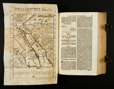
The map first appeared in Stocklein's Allerhand So Lehr-Als Geist-Reich Brief . . . , published in Augsburg in 1726 in 6 parts and then augmented in with an additional 2 parts. We offer here an example of the second edition of the book, published in 1728 and containing 4 of the original 8 parts bound as a single volume, comprising volume 1 of the second edition. This first volume includes the accounts of California, New Mexico, Mexico and Panama, including a reprint of P.Francisco Maria Picolo's Informe, which is widely regarded as the first printed account of California. The volume includes 7 maps and plates, including the seminal Kino map.
![[ Sonoma County ] Map of Sonoma County California Showing New Boundary Lines of County and Townships, Private Claims and Ranches, Government Townships and Section Lines, Rail Roads and Public Roads Water Works Cities Towns School Districts, etc. Carefully Compiled From The Latest Authorities By R.A. Thompson, County Clerk . . . 1884](https://storage.googleapis.com/raremaps/img/small/99877.jpg)

![[WWII War Bonds] As](https://storage.googleapis.com/raremaps/img/small/63461.jpg)