|
||

|

|
|

|
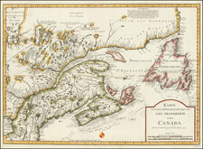
One of the earliest obtainable maps of the state. Shows counties, towns, roads, rivers, lakes, islands, court houses, churches, and other early details. The map erroneously follows the Byram River a bit too far, based upon an error made by Benjamin Tanner in the 1796 Reid map. Wheat & Brun 292. This map appeared in Volume IV of John Payne's New and Complete Universal Geography… published in New York by John Low at the Shakespeare Head, No. 332 Water-Street, in 1799. Following the publication of Carey's American Atlas in 1795, there were a small group of 18th Century works which included a complete set of state maps, including John Reid's American Atlas, Joseph T. Scott's Gazetteer, Carey's Pocket atlas and works by Jeddidiah Morse. This small group of maps and the few separately issued maps of the region, which are now virtually unobtainable, mark the beginnings of the indigenous cartographic publishing business in America, and are now highly sought after.