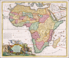
![Africa / Lybia / Morland / mit allen kunigsreichen so zu unsern zeiten darin gefunden werden [Afrika/Libyen/Morenland, with all the kingdoms found therein in our time] By Sebastian Munster](https://storage.googleapis.com/raremaps/img/small/95771.jpg)


|
||

|

|
|

|
A nice full color example of Munster's map of Africa, from an early edition of Munster's Cosmographia.
One of the first modern maps of the whole continent. The Ptolemaic geography, with large rivers and convoluted mountains, is augmented from Portuguese and Arabic sources. From the Portuguese comes Caput Bonespei (Cape of Good Hope) and a small group of islands off the eastern coast named Zaphala Aurifodina that were supposedly the region from which King Solomon imported gold and silver. The Arab kingdoms of Quiola (printed upside down) and Melinde appear in eastern Africa and Hamarich, the capital of the mythical Christian king Pester John, is shown at the confluence of the twin sources of the Nile.
The map is illustrated with crowns and scepters, forests, parrots, an elephant, a Cyclops ( Monoculi) and a large galleon under full sail.
Sebastian Münster (1488-1552) was a cosmographer and professor of Hebrew who taught at Tübingen, Heidelberg, and Basel. He settled in the latter in 1529 and died there, of plague, in 1552. Münster made himself the center of a large network of scholars from whom he obtained geographic descriptions, maps, and directions.
As a young man, Münster joined the Franciscan order, in which he became a priest. He then studied geography at Tübingen, graduating in 1518. He moved to Basel, where he published a Hebrew grammar, one of the first books in Hebrew published in Germany. In 1521 Münster moved again, to Heidelberg, where he continued to publish Hebrew texts and the first German-produced books in Aramaic. After converting to Protestantism in 1529, he took over the chair of Hebrew at Basel, where he published his main Hebrew work, a two-volume Old Testament with a Latin translation.
Münster published his first known map, a map of Germany, in 1525. Three years later, he released a treatise on sundials. In 1540, he published Geographia universalis vetus et nova, an updated edition of Ptolemy’s Geographia. In addition to the Ptolemaic maps, Münster added 21 modern maps. One of Münster’s innovations was to include one map for each continent, a concept that would influence Ortelius and other early atlas makers. The Geographia was reprinted in 1542, 1545, and 1552.
He is best known for his Cosmographia universalis, first published in 1544 and released in at least 35 editions by 1628. It was the first German-language description of the world and contained 471 woodcuts and 26 maps over six volumes. Many of the maps were taken from the Geographia and modified over time. The Cosmographia was widely used in the sixteenth and seventeenth centuries. The text, woodcuts, and maps all influenced geographical thought for generations.
![[ Atlas of Africa ] L'Afrique en Plusieurs Cartes Nouvelles, et Exactes; &. En Divers Traictes de Geographie, et D'Histoire.](https://storage.googleapis.com/raremaps/img/small/68986.jpg)