|
||

|

|
|

|
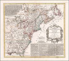
Rare first state of Basset's map showing the theater of war in America during the American Revolution.
The map covers the region from Newfoundland to northern Florida, and west as Lake Michigan. There is a large inset of southern New England and New York, eastern Pennsylvania and all of New Jersey that features the region most affected by the Revolution in 1779. The map is filled with topographical information, boundaries, cities, towns, forts, Indian territory and villages, battlefields, trails and roads.
The large title cartouche includes a battle scene, the personification of America as an Indian queen and the royal British coat of armsThe maps was separately published by Basset.
Louis Denis (1725-1794) was a French geographer and cartographer best known for his incomplete road atlas of France, Le Conducteur français. Originally trained as an engraver, he partnered with Louis-Charles Desnos to create and edit maps. Later, Denis served as geography tutor to the children of the French royal family. His pupils included the Duc de Berry, the future Louis XVI.
![A New and Correct Map of North America with the West India Islands, Divided According to the Last Treaty of Peace ... 20th of Jan. 1783 ... Particularly Distinguished the Thirteen Provinces which Compose the United States . . . [With annotations describing Cumberland, Tennessee, Kentucky etc.]](https://storage.googleapis.com/raremaps/img/small/41651.jpg)
![A New Map of Virginia [Chesapeake]](https://storage.googleapis.com/raremaps/img/small/43053.jpg)