


|
||

|

|
|

|
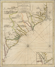
First state of Mortier's map of the Carolinas, the French edition of Thornton, Morden & Lea's virtually unobtainable map of the region, first published in 1685.
Cumming observed that the two maps are identical to the smallest geographical detail and provide the most complete and up to date view of the Carolinas available at the end of the 17th Century. The original counties are named, and numerous estates and plantations are identified.
Inset of Charleston, founded in 1669. One of the earliest obtainable maps of the region to reflect any significant settlement. Extends from Albermarle County to south of the Savannah River.
A very nice example, lacking the plate number that distinguishes this map from the 2nd State.
Pierre, or Pieter, Mortier (1661-1711) was a Dutch engraver, son of a French refugee. He was born in Leiden. In 1690 he was granted a privilege to publish French maps in Dutch lands. In 1693 he released the first and accompanying volume of the Neptune Francois. The third followed in 1700. His son, Cornelis (1699-1783), would partner with Johannes Covens I, creating one of the most important map publishing companies of the eighteenth century.
![(Carolinas) Virginiae Partis australis, et Floridae partis orientalis, interjacentiumqus regionum Nova Descriptio [A New Description of the Southern Part of Virginia and the Eastern Part of Florida, and the Intervening Regions.]](https://storage.googleapis.com/raremaps/img/small/94131.jpg)

![(Civil War) Fredericksburg … [with] Map… of the Sioux Expedition [with] Map of the Fight of the 14th A.C. Buzzard Roost, GA [and ] Big Mound [and] Dead Buffalo Lake [and] Dry Fort Creek](https://storage.googleapis.com/raremaps/img/small/97072.jpg)

![[ Florida Indians - Destroying the Enemy's Towns By Night ] Hostium oppida noctu incendendi ratio. XXXI.er absagen](https://storage.googleapis.com/raremaps/img/small/97385.jpg)