|
||

|

|
|

|
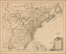
Rare unfolded example of Traugott Bromme's map of the US, published by JE Woerl.
Bromme was one of the most prolific German Travel writers from the 1830s to 1850s. His guides to German Emigrants, issued in many forms and abridgements, are now highly coveted. In a few of these guides, Bromme offered deluxe editions of the Guide, with a map published by JE Woerl. This is the earliest example of the map which we have ever seen, predating the examples which show counties in Texas. Rumsey has high marks for the map, calling it a beautifully engraved map of the US, from Coast to Coast, based upon Brue's map of Mexico from 1834 and Brue's Map of North America from 1833, although lacking Smith's Route. The cartography is pre-Fremont.
Excellent detail in present in the Pacific Northwest, Missouri Valley and Southeast. Texas is shown as a newly formed Republic, but pre-dating the appearance of counties. Excellent detail along the Rio Colorado, especially in the largely mythical headwaters west of the Rocky Mountains. Two Salt Lakes are prominently shown, along with the remnants of several mythical western rivers. The Puget Sound, Columbia and Frasier River treatment is also excellent. Shows many Indian Tribes, Forts, Roads, Lakes, Rivers, Mountains and other places of interest. Massive Missouri Territory dominates the mid-Continent.
![Gen. Washington [On The Battlefield At Trenton] Engraved by W. Warner from the original picture by Col John Trumbull](https://storage.googleapis.com/raremaps/img/small/103233.jpg)
![[ Southern Railroads ] Railroad Map of the Southern States Shewing the Southern & Southwestern Railway Connections With Philadelphia. 1862 . . . Prepared by Thomas Kimber Jr., Chairman of the Committee on Inland Transportation of the Board of Trade of Philadelphia](https://storage.googleapis.com/raremaps/img/small/103211.jpg)
![[ First Map to Name The United States ] L'Amerique septentrionale ou se remarquent les Etats Unis . . . 1779](https://storage.googleapis.com/raremaps/img/small/94192.jpg)