


|
||

|

|
|

|
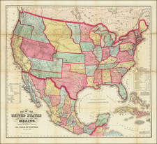
A toned example of one of the rarest and most decorative French Maps of the US from the mid-19th Century. The map includes Classic Territorial Cartography of the period, including Oregon and Washington Territories extending to the Rocky Mountains, post-Gadsden Purchase border with Mexico, although the pre-Purchase border is also shown. Massive Utah and New Mexico Territorial configurations, Kansas extends to Colorado and Nebraska runs to Canada. Excellent detail in Texas, including early roads. The map includes a hand sketched route from New York to San Francisco, via Chicago, Omaha and Salt Lake. Elegantly colored, with Garnier's tradmark title vignette. Garnier's atlas is rare and highly sought after for its fine colors and elegant engraving style. Normally a $400 map.

![[All The Way With LBJ - 1964 Presidential Election Campaign Poster] Johnson Humphrey for the USA](https://storage.googleapis.com/raremaps/img/small/88907.jpg)