


|
||

|

|
|

|
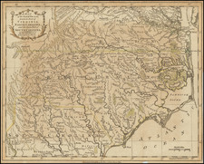
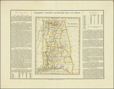
Rare German edition of Carey & Lea's map of Alabama. Shows numerous early oversized counties and Indian Lands, including a massive Upper Creek region on the Georgia Border, with Cherokee Lands above. The western boundary with Mississippi includes Chocktaws Lands. The southeastern area on the Gulf Coast is called West Florida, but colored to show it as part of Alabama. Jackson's Route to New Orleans is shown, along with many early roads, towns, forts and other features. Carey & Lea published the Atlas of North America in 1822. The atlas was a commercial success and was re-issued in 1823 and 1827. It adopted the style of the Lavoisne Atlas, which had been published in London and later in Philadephia by Carey & Lea, with descriptive text on two or three sides of the maps, rather than on the verso or other pages. A French edition of the Atlas was published by Buchon in Paris in 1825. This German edition by Weiland is by far the rarest. All of the maps have been re-engraved by the Weimar Geographischen Insitut, a well regarded cartographic publisher. The engraving quality of the maps far surpasses the American edition. Weiland actually added several maps which did not appear in the Carey & Lea or Buchon additions. One of the earliest and rarest maps of the state printed outside the US.