|
||

|

|
|

|
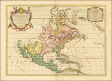
Dezauche's scarce re-issue of this extremely important map, exhibiting the Russian discoveries in 1723, 1732 and 1741, Bering's tracks from his first and second voyages and of De L'Isle de la Croyere with Captain Tchirikow in 17641.
Also shows the track of de Frondt's voyage of 1709 and the route of the Manilla Galleons in 1743. Water of Wager discovered in 1746 and 1747.
Joseph De L'Isle spent much of his career in Russia, producing the Atlas Russicus (the first Russian atlas) with Ivan Kyrilov and founding the Academy of Sciences of St Petersburg. He returned to Paris is 1747 with a large map collection, including the manuscript of this map of the North Pacific. In 1750 he presented the map to a public assembly of the French Academy of Sciences.
Exrtending to Korea in the west and showing the whole of North America, it marks out the supposed discoveries of Admiral de Fonte, including a vast inland sea, the Mer de L'Ouest, to the North of California, a waterway from the Pacific almost to Baffin's Bay, and a large landmass in the middle of the Pacific.
A landmark map in the history of cartography.
Jean-Claude Dezauche (fl. 1780-1838) was a French map publisher. Initially, his work focused on engraving music, but he later turned primarily to cartography. His is best known for editing and reissuing the maps of Guilluame De L’Isle and Philippe Buache, two of the most skilled mapmakers of the eighteenth century. He acquired the plates of these two men’s work in 1780 from Buache’s heir, Jean-Nicolas Buache. Dezauche's business received a further boon when he received a privilege to sell the charts of the Dépôt de la Marine. His business was carried on by his son, Jean-Andre Dezauche.

![[Glaciers & Polar Ice Packs, etc.] Arctic Ocean Greenland](https://storage.googleapis.com/raremaps/img/small/79033.jpg)

![America [Manuscript Map Showing the Sea of the West!]](https://storage.googleapis.com/raremaps/img/small/41297dm.jpg)