|
||

|

|
|

|
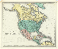
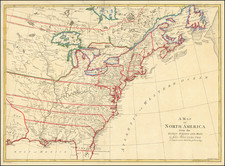
Scarce map of North America, on the eve of Texas Independence.
The map is remarkably detailed, especially in the West. Texas is Santander, with a Free Indian region in the north. Many place names present. Northwest of Texas, there is a significant amount of Indian and topographical details, more so than on most maps of the period. Oregan Territory includes the details from Lewis & Clark, the Astorians, and other early explorations in the region, along with lots of Indian details. Extraordinary detail in Upper California, including the Missions, mythical rivers, notes on the Russian Settlements near San Francisco, and excellent detail north of the Gila River. Highly details NW Coast of America, including American, British and Russian settlements and forts, Indian Tribes, etc. Nice detail in Alaska, which is Polar Kreis. Massive Northwest and Missouri Territories shown.
Weiland's maps are quite scarce, this being the first example we have handled of this 1834 edition. One of the most detailed western maps of the period. Not in Wheat.
![[Revolutionary War Plans of New York, Boston, Charleston, Delaware River to Philadelphia & Havana] Various Plans and Draughts of Cities, Towns, Harbours &c . . .](https://storage.googleapis.com/raremaps/img/small/83450.jpg)