This item has been sold, but you can enter your email address to be notified if another example becomes available.


|
||

|

|
|

|
Stock# 1630
Description
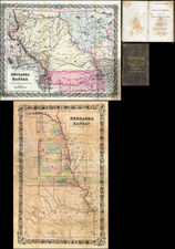
Large attractive 5 color map of Oklahoma divided in half (the 2nd half being Indian Territory) from the 11th Census' Indians Taxed and Not Taxed Report. The Creek and Chickasaw Nations are divided into districts and the Choctaw Nation into early counties. Guthrie and Tulsa are now present. Extraordinarily detailed. Extensive marginal notes, including a table of 13 railroads w/in the Territory. A fine copy of one of the great Oklahoma/Indian Territory maps of all time. Fitch, Catalogue No. 54.
![Mexico [Texas on the Eve of Independence]](https://storage.googleapis.com/raremaps/img/small/84917.jpg)
![[Arizona below New Mexico] Mexique d'apres le grand Atlas Dresse Par A.H. Dufour Grave par ch Dyonet Pubie par A. Le Chevalier . . . 1863](https://storage.googleapis.com/raremaps/img/small/64395.jpg)