


|
||

|

|
|

|
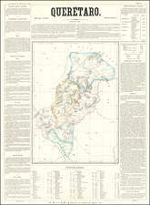
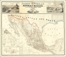
Scarce map of the State of Queretaro in Mexico, from Garcia y Cubas' monumental Atlas Geographico, Estadistico e Historico de la Republica Mexicana. Garcia y Cubas was Mexico's first great lithographer and his work is highly sought after. This map shows the veraious regions within the state, towns, roads, rivers, etc. The surrounding text includes a wealth of information regarding Queretaro, incluing History, Climate, Agriculture, Minerals, Livestock, Commerce, Population and Itineraries. A bit of dampstaining, but still a nice example of this rare. Only 300 examples of the atlas were reportedly printed and separate maps rarely appear on the market.
Antonio García y Cubas (1832-1912) was a Mexican geographer, historian, writer, and cartographer. An orphan from a young age, Cubas attended the Colegio de San Gregorio and the Colegio de Ingenieros, where he earned a geography degree. In 1856, he became a member of the Sociedad Mexicana de Geografía y Estadística.
Cubas wrote several geographic works, including introductory courses to geography, historical atlases, and maps. He is best known for his Atlas Geográfico, Estadístico e Histórico de la República Mexicana (1857), Carta General de México (1863), and Diccionario Geográfico, Histórico y Biográfico de los Estados Unidos Mexicanos en cinco volúmenes, editados entre 1888 y 1891. He is also praised for his memoir, El Libro de mis Recuerdos (1905). Today, the best books published in anthropology and history in Mexico are given the Antonio García Cubas prize.
![(Mexican-Aztec Painting) [Watercolor of Aztec Deities from the Codex Telleriano-Remensis and Codex Vaticanus]](https://storage.googleapis.com/raremaps/img/small/103008.jpg)
![[ Baja California / Mexico ] Carta particolare della parte ocidentale della nuova Spagnia, e del la California . . . D'America Carta XXXI](https://storage.googleapis.com/raremaps/img/small/101394.jpg)