![Amerique Septentrionale divisee en Ses Principales parties . . . . 1692 [California as an Island] By Alexis-Hubert Jaillot](https://storage.googleapis.com/raremaps/img/small/95812.jpg)


|
||

|

|
|

|
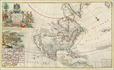
Spectacular example of Jaillot's map of North America, showing California as an Island, based upon Sanson's landmark map of 1656. This map and a smaller version went through a number of variants, this example shows the open Great Lakes on the west end, as was the norm in the earlier examples (although curiously enough the open ended Lakes also show up in some later examples of the map). The source of the Mississippi is pushed far west of its true location. The east coast of North America is based upn Sanson, although the projection of California is his second projection, differing from the 1656. This example is in gorgeous full color. We have had this large example 2 or 3 times in the past 10 years, but this is without doubt the finest and most visually appealing.
Alexis-Hubert Jaillot (ca. 1632-1712) was one of the most important French cartographers of the seventeenth century. Jaillot traveled to Paris with his brother, Simon, in 1657, hoping to take advantage of Louis XIV's call to the artists and scientists of France to settle and work in Paris. Originally a sculptor, he married the daughter of Nicholas Berey, Jeanne Berey, in 1664, and went into partnership with Nicholas Sanson's sons. Beginning in 1669, he re-engraved and often enlarged many of Sanson's maps, filling in the gap left by the destruction of the Blaeu's printing establishment in 1672.
![[Fruit Crate Label Advertising Map] Panama Brand (North America & Panama Canal)](https://storage.googleapis.com/raremaps/img/small/48860.jpg)