


|
||

|

|
|

|
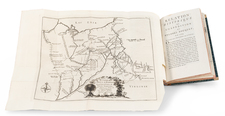
One of the earliest obtainable separate maps of Minnesota to appear in a commercial atlas and the earliest to appear in an Atlas published outside the United States. Includes interesting annotations in the west and early primitive counties. One of the rarest of all US Atlases is the Rogers & Johnston Atlas of the United States &c. Conceived as a collaborative effort between W & AK Johnston (of London) and H.D. Rogers (of Boston), the project began with a wonderful wall map of the United States in 1856, which Rumsey describes as one of the most beautiful maps of the period. Unfortunately, neither the wall map nor the subsequently produced atlas achieved wide commercial success, despite its fine detail and engraving style. Complete examples of the Atlas are rare on the market. This southeastern map shows the various counties in outline color and names towns, rivers, lakes, islands, railroads, swamps etc. Rogers & Johnston maps are an essential part of a comprehensive mid 19th Century American map collection, representing the only attempt by the British at a comprehensive treatment of the US in Atlas format.


![[French & Indian War] Carte Des Possessions Francoises et Angloises dans le Canada et Partie de la Louisiane . . . 1756](https://storage.googleapis.com/raremaps/img/small/94026.jpg)