


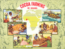
|
||

|

|
|

|
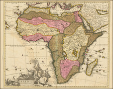
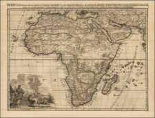
Striking copper plate engraved map of all of Africa from Nicholas de Fer's L'Atlas Curieux ou le Monde. This example is the third state, dated 1717.
A wonderful blend of known, conjectured, and mythical features, the map has a curious depiction of the continent with a bulge in the southwest coastline between the Cape and the Congo. Unusual islands appear in the Atlantic and Indian Oceans, including the second mythical island of St. Helena. In Central Africa there is a paragraph concerning the origin of the Nile in Abyssinia; the source of the Nile is close to correct, but the original and two mythical lakes remain. Ptolemy's lakes of Zaire and Zaflan are depicted entirely divorced from the Nile. "Monomotapa" is shown in the south and at the Cape of Good Hope there is a description about the circumnavigation by Diaz in 1486.
The map is graced with a decorative dedication to the Dauphin and a title cartouche featuring lime kilns, as well as a compass rose.
Nicholas de Fer (1646-1720) was the youngest son of Parisian print and map seller, Antoine de Fer [d.1673]. He became an official geographer to both French and Spanish kings. Nicholas de Fer was one of the most prolific and influential French geographers and cartographers of the late 17th and early 18th Century.
Nicholas de Fer (1646-1720) was the son of a map seller, Antoine de Fer, and grew to be one of the most well-known mapmakers in France in the seventeenth century. He was apprenticed at twelve years old to Louis Spirinx, an engraver. When his father died in 1673, Nicholas helped his mother run the business until 1687, when he became the sole proprietor.
His earliest known work is a map of the Canal of Languedoc in 1669, while some of his earliest engravings are in the revised edition of Methode pour Apprendre Facilement la Geographie (1685). In 1697, he published his first world atlas. Perhaps his most famous map is his wall map of America, published in 1698, with its celebrated beaver scene (engraved by Hendrick van Loon, designed by Nicolas Guerard). After his death in 1720, the business passed to his sons-in-law, Guillaume Danet and Jacques-Francois Benard.
![Africa / Lybia / Morland / mit allen kunigsreichen so zu unsern zeiten darin gefunden werden [Afrika/Libyen/Morenland, with all the kingdoms found therein in our time]](https://storage.googleapis.com/raremaps/img/small/95771.jpg)