


|
||

|

|
|

|
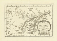
Detailed map of Quebec, colored by counties. Inset of the Environs of Montréal. Includes nice detail, especially along the St. Lawerence, including towns, rivers, lakes, railroads, roads, etc. The counties show uncertain Northern boundaries on the North side of the River, as the region becomes essentially unsurveyed territory.
Samuel Augustus Mitchell Jr. inherited the Mitchell Company from his father in 1860. For over thirty years, the company had specialized in the production of school atlases and wall maps of America. They were one of the pioneers on engraving on steel plates. In 1860, Samuel Jr. released the New General Atlas, which had been compiled in house and replaced a previous atlas by Tanner. The elder Mitchell died in 1868 and Samuel Jr. continued the business until the 1890s. At its height, the Mitchell Company employed 250 people and sold 400,000 publications annually.
![[Untitled Map of The Atlantic Ocean, Europe, Africa, the Middle East, and Eastern Canada]](https://storage.googleapis.com/raremaps/img/small/89582.jpg)
![Amer. Sep. No. 19 & 20 [Partie du Groenland and Groenland Orientale]](https://storage.googleapis.com/raremaps/img/small/19107.jpg)
![[ Karte des Nordens von America, Zur Beurtheilung der Wahrscheinlichkeit einer nord=westlichen Durchfhart, gezeichnet von G. Forster, 1791.]](https://storage.googleapis.com/raremaps/img/small/41816dm.jpg)