


|
||

|

|
|

|
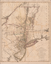
Important early Revolutionary War map, published one day prior to the signing on the Declaration of Independence. The map was published by William Faden and appears in his very rare North America Atlas. Shows New York, Long Island, New Jersey and parts of Pennsylvania, Maryland and southern New England, based upon the actual surveys by Sauthier, with New Jersey added from the topographical observations of Sauthier and Ratzer. Includes Martha's Vineyard, Long Island, Boston, northern Chesapeake Bay, Annapolis and extends north to show Montreal. A fascinating and detailed look at the towns, villages, military posts and forts, manors, roads, churches, rivers and ferries at the beginning of the Revolutionary War. Locates Dartmouth College and settlements along the Connecticut River. Features the disputed line of partition between New York and New Jersey and early county boundaries in New York. A highly detailed and important map. A few minor tears, just entering the printed image and some minor restorations along the right margin, but generally a nice example. Schwartz & Ehrenberg 187-88; Sellers & Van Ee 1047.

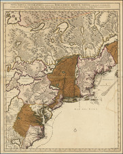
![[ Inhabitants of New Netherlands ] Einwohner in Neu Niederland](https://storage.googleapis.com/raremaps/img/small/94087.jpg)