|
||

|

|
|

|
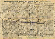
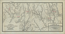
Important early map of the gold region in California, published shortly after the discovery of gold in California.
Striking map of the gold region, showing region from San Francisco and Monterey Bays in the west to the western slope of the Sierras. Special emphasis on the Diggings and Mother Lode countries, whcih are described as a range of hills 300-800 feet high, sparsely covered with oak and pine timber. The map illustrates the diggings along the America River, early roads, towns, rivers, etc, including Scollerville, Green Spring, Colluma, Jonestone, Corons, Angel's, Sororam Camp, Sullivan's, Curtis, Woods, Tent, Maj. Miller's Camp, M.Kenzie's Ranch, Stockton, Daly's Mill, etc. General Riley's route through the region is tracked on a daily basis.
Derby's map is significant not only for recording the tour of the gold fields by General Riley upon his appointment as California's first "civilian" governor, but also for the new information it presents. Wheat notes that "Derby accompanied General Bennet Riley on his trip through the gold diggings . . . , and although his map shows only a portion of the 'Mining Districts,' it is important since on it appear for the first time several names of certain actual mining camps in the middle of the Sierra foothills. Among these are Mormon Island (misspelled 'Mormont' by the eastern lithographer who copied Derby's sketch), Coloma (mislabeled 'Colluma'), Curtis, Sullivan's, Corons, Jamestown, Woods, Sonora, and Angel's,-and one doubtless accurately labeled only 'Tent.' Some of these names have not survived, but Derby's map graphically shows how the miners were beginning to swarm up the Sierra streams into the general area which he designated as 'Diggings.' The entire route of the Riley party is noted, with the dates of their visits to the various points."