


|
||

|

|
|

|
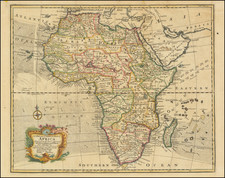
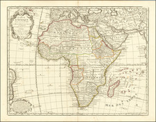
Decorative and detailed map of Africa, exhibiting the present knowledge of Europeans in the first half of the 18th Century. The cartography along the coasts is relatively accurate, but the interior is still largely myth and conjecture. Large decorative cartouche and a second decorative advertisement in the lower left corner. Margins trimmed on all sides, with minor loss of image inside the neatline, and one small stain, but in all a good example. Based upon the work of Guillaume De L'Isle.
Philippe Buache (1700-1773) was one of the most famous French geographers of the eighteenth century. Buache was married to the daughter of the eminent Guillaume Delisle and worked with his father-in-law, carrying on the business after Guillaume died. Buache gained the title geographe du roi in 1729 and was elected to the Academie des Sciences in the same year. Buache was a pioneering theoretical geographer, especially as regards contour lines and watersheds. He is best known for his works such as Considérations géographiques et physiques sur les découvertes nouvelles dans la grande mer (Paris, 1754).
![[Africa] Prima Tavola](https://storage.googleapis.com/raremaps/img/small/96586.jpg)