


|
||

|

|
|

|
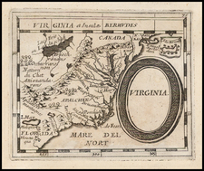
Rare unrecorded edition Purcell's map of the Southeast, which includes an early reference to the New State of Franklin in Western Carolina and Eastern Tennessee. This map first appeared in Jeddidiah Morse's American Georgraphy and in some copies of the August 1788 edition of the American Magazine. Later examples were issued by Stockdale in London. However, an inspection of the recorded examples indicates that the example offered here is neither a recorded American or English edition, as the information on both land and sea have been changed from these recorded examples, primarily in the orientation of the text. Shows the boundaries between the US and Spanish Dominions, lines delimiting Indian Nations,, Towns, Roads, Indian Villages and host of other early details, including counties, Indian Trade paths, the Seven Ranges, Ekanfanoka Swamp (Okenfenokee), Port Vincient (Vincennes), The Ohio Company, New Jersey Company and Illinois Company Lands are shown, as are the Donation Lands of the Commonwealth of Virginia. Many other interesting details. Wheat & Brun 491, 494.


![[ Virginia / Maryland / Chesapeake Region ] Pas Kaart van de Zee Kusten van Virginia Tusschen C. Henry ent Hooge Land van Renslaars Hoek. . .](https://storage.googleapis.com/raremaps/img/small/47255.jpg)