
The item illustrated and described below is sold, but we
have another example in stock. To view the example which
is currently being offered for sale, click the
"View Details" button below.
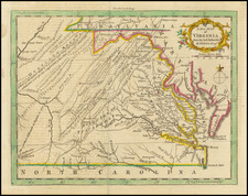
![Map of the States of North & South Carolina [Large Charleston Inset] By Hinton, Simpkin & Marshall](https://storage.googleapis.com/raremaps/img/small/91846.jpg)
1832 Hinton, Simpkin & Marshall
$ 345.00


|
||

|

|
|

|
Stock# 15578
Description
Scarce early map of the Carolinas, hand colored by counties. Primitive county configurations still appear in the west. Shows towns, roads, rivers, mountains, lakes, post offices, court houses, rivers, Indian Villages, forts, etc. Excellent plan of Charleston, predating the earliest plan to appear in an American Atlas. Highly detailed map, showing towns, Indian Villages, forts, roads, rivers, mountains, lakes, etc. One of the earliest separate maps of these states published outside of America. Gorgeous full color example. Full color examples are rare on the market.

![(The First Letter From British Florida) [September 5, 1763, Autograph Letter, Signed, from Robert Campbell to John Campbell, 4th Earl of Loudoun, describing the British taking possession of Florida and the state of the settlement of Pensacola]](https://storage.googleapis.com/raremaps/img/small/86620.jpg)