![Affrika třetj djl okrsslku zemského [Czech Language Edition] By Heinrich Bunting](https://storage.googleapis.com/raremaps/img/small/93470.jpg)


|
||

|

|
|

|
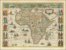
Rich dark example of Heinrich Bunting's scarce map of Africa, from a German edition of his Itinerarium Sacræ Scripturæ. The Nile finds its source in the mountains of the moon. Elephantophagi is shown in West Africa. Several large cities and kingdoms noted. The map is based largely upon Munter's map, first issued in 1540. Large sailing ship and sea creatures embellish the map. Minor repaired wormhole, else a fine dark example. Norwich 17. Not in Tooley.
Henrich Bunting was a Protestant theologian and teacher born in Hanover, in what is now Germany. He attended the University of Wittenberg and graduated in 1569. He then began work as a preacher but caused some controversy with his teachings; he was dismissed from appointments in both Lemgo and Goslar.
He is best known today for his book, Itinerarium Sacrae Scripturae (Travel book through Holy Scripture), a travel collection and commentary of the geography of the Bible. The book provided the most complete summary of biblical geography then available and described the Holy Land by following the travels of various notable people from the Old and New Testaments. First published in Madgeburg in 1581, Itinerarium Sacrae Scripturae was a very popular book for the time. Over 60 editions were published between 1581 and 1757.
A particularly notable feature of the book were its many woodcut maps, many of them showing unique depictions of geographic features and continents. In addition to the conventional maps, the book also contained three figurative maps; the world depicted using a cloverleaf design (thought to possibly represent the Trinity with Jerusalem in the center), Europe in the form of a crowned and robed woman, and Asia as the winged horse Pegasus.

![[Untitled Map of The Atlantic Ocean, Europe, Africa, the Middle East, and Eastern Canada]](https://storage.googleapis.com/raremaps/img/small/89582.jpg)