


|
||

|

|
|

|
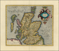
Map of Scotland engraved by William Hole (one of the earliest English engravers) for the first illustrated edition of William Camden's Britannia, originally published in 1607 with Latin text. This example accompanied the English translation printed in 1610 and again from the same plates in 1637. The strength of this impression indicates it is a 1610 example, but there is slight chance it is the latter. The English editions have no text on the reverse.
Hole fashioned his double-page map of Scotland after the Mercator map of 1595 and the work of Saxton.
Hole's map was followed by John Speed's "The Kingdom of Scotland".
First published in 1586, Camden's Britannia provided a history of Britain from pre-Roman times. However, not until the 1607 edition, shortly before his death, did Camden included maps of English and Welsh counties as well as maps of Ireland and Scotland. In fact, Britannia was the first British atlas to feature a separate map of Scotland, making this the first map of Scotland made by an Englishman in England.
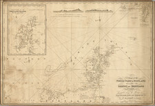
![[ Scotland ] North Britain or Scotland Divided into its Counties Corrected from the best Surveys . . .](https://storage.googleapis.com/raremaps/img/small/102877.jpg)
![[Scotland] Scotiae Tabula](https://storage.googleapis.com/raremaps/img/small/35612.jpg)