
The item illustrated and described below is sold, but we
have another example in stock. To view the example which
is currently being offered for sale, click the
"View Details" button below.
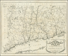
1797 Amos Doolittle
$ 1,800.00


|
||

|

|
|

|
Stock# 15345
Description
One of the earliest maps of Connecticut printed in America. Includes excellent detail throughout, including towns, roads, court houses, meeting places, rivers, lakes, islands, etc. Decorative title cartouche incorporates the coat of arms of Connecticut. A nice example, in original outline color. Narrowm margins, left and right, as issued. Wheat & Brun 291; Thomson 43; McCorckle 797.1


![Carte Reduite Des Costes Orientales De L'Amerique Septentrionale . . . contenant L'Isle Royale . . . La Nouvelle Angleterre et la Nouvelle Yorc . . . MDCCLVII [with Plan of Boston Harbor] Plan du Havre de Baston](https://storage.googleapis.com/raremaps/img/small/80006.jpg)
![(Coast of Florida, Georgia and the Carolinas] [To The Members Of The Nautical Institution And Ship-Masters' Society Of The City Of New York, This Chart, Extending From Lat. 40°15 N., Long. 72°15 W., to Lat. 22°35 N., Long. 80°25 W., Is Respectfully Dedicated / By Their Obedient Servant Edmund M. Blunt]](https://storage.googleapis.com/raremaps/img/small/77294.jpg)
