|
||

|

|
|

|
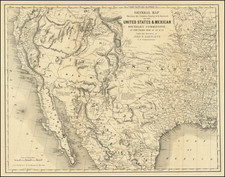
Nice example of Jacob De Cordova's map of Texas, the single most influential map of Texas immediately following Statehood.
Jacob De Cordova was an early Texas land promoter and early developer. De Cordova and Robert Creuzbaur, an employee of the newly created General Land Office, compiled this map using latest surveys and drawing it on a scale far larger than any prior map of the State. First issued in 1849, it was one of the first major cartographic productions after Texas annexation into the United States to be based upon the records of the General Land Office. De Cordova was one of the earliest Jewish settlers in Texas. During the War for Texas Independence, he supplied goods from New Orleans, before settling in Galveston in 1837. He quickly took to his adopted homeland, adding several Indian dialects to the 5 languages which he spoke prior to his arrival.
After serving a term in the Texas House of Representatives, De Cordova settled in Austin, where he and his brother published the Texas Herald. Anticipating a land boom in Texas following the Mexican War, he began speculating in land and for the next 30 years, he actively promoted immigration to Texas, including promotional tours of the United States and Europe. As part of this campaign, he produced his first map of Texas in 1849. Sam Houston persuaded Congress to purchase 500 copies of the 1849 edition, arguing with Jefferson Davis in support of the quality of the map and character of De Cordova during the appropriations process on the floor of the Senate.
There are a number of editions of this map. From 1849 to 1854, De Cordova published the map himself, updating it between each edition. In 1856, he assigned the rights to J.H. Colton, who published the subsequent editions up to 1872. The present example is the third edition. This is the first edition of the map to show the Texas Panhandle (which appears in the inset). Within the oval inset map, the new boundaries of Texas are shown for the first time following the Compromise of 1850, and the organization of Utah and New Mexico Territories, the latter of which curiously extends from Texas to the Pacific Ocean, encompassing all of southern California.

![Map of Texas [with] inset of N.W. Part of Texas](https://storage.googleapis.com/raremaps/img/small/84519.jpg)