This item has been sold, but you can enter your email address to be notified if another example becomes available.


|
||

|

|
|

|
Stock# 15122
Description
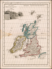
Detailed map of Ireland, hand colored by counties and showing towns, rivers, lakes, islands, et cetera. Notes on the various provinces, archbishops, bishops, episcopal sects, boroughs, counties and the university. Robert Wilkinson was active in London as a cartographic publisher from 1785 to 1825. He produced a number of nice works, including a General Atlas and a re-issuance of Bowen & Kitchen's English Atlas, along with excellent large format separate maps.