|
||

|

|
|

|
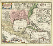
Rare late edition of Streit's fascinating map of the United States with inset maps of the region around Washington DC, Boston, Philadelphia and New York.
The map is not only rare, it includes nice detail, including Forts, Indian Villages, Towns, Roads, Railroads, Canals, Waterfalls, Ports, Universities and Colleges and other features. Very nice detail along the Upper Missouri River and in Oregon Territory. The west is configured as it appeared immediately before the Treaty of Guadalupe Hidalgo, with Texas still shown as a Republic, albeit 2 years after it gained admission into the Union. Two Salt Lakes and rivers connecting each to the Pacific Ocean are prominent in the Cartography of California. Texas' border appears to track the Red River, unliked earlier editions of the map which tracked the Nueces. The French Colony, Mainzer Colony in Texas are shown and boundaries included. Several Plains Indian boundaries are shown, along with Lewis & Clark notes. The first time we have ever seen this 1848 example. We handled the 1842 edition in 1999.
![(Texas Photograph) [Cabinet Card Birdseye View of El Paso, Texas and Ciudad Juarez]](https://storage.googleapis.com/raremaps/img/small/92983.jpg)