


|
||

|

|
|

|
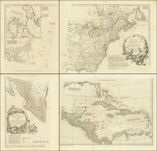
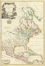
Nice example of Senex's wall map of North America, dedicated to Anthony Hammond, Commissioner in Her Majesty's Navy. The map is one of the earliest large-scale English maps of North America.
The map represents a British attempt to consolidate new information about the region and borrows data from such recently published sources as Delisle's landmark Carte du Mexique et de la Floride and Carte de la Canada. Senex improves upon this work with a fine depiction of the Great Lakes region and the most accurate definition of the lower Mississippi River and its delta by an English cartographer of the period. Several of the most important and controversial cartographic discoveries of the period are discussed at length, including Lahontan's mythical Long River and the Salt Lake east of the Country of the Mozeemleck's, both of which are also depicted in remarkable (albeit fanciful) detail. Sir William Phipps discovery of Spanish wrecks off the coast of the Caicos and Southern Bahamas is also noted. Senex also extended the map's coverage to the Canadian Arctic and the Terra Incognita above Baffin's Bay. Present-day Oklahoma and Texas are part of La Floride, considered at the time to be a possession of the French. The Red River and the Indian villages of East Texas are portrayed accurately, but Senex, following Delisle, incorrectly placed many Texas rivers, in addition to depicting some strange and unrecognizable names.
One of the most remarkable large format English maps of the period, embellished with a large cartouche and coat of arms. The present example is a variant edition not described by Stevens & Tree, lacking the Maxwell credit, dated 1710, but without the T. Bowles credit.
John Senex (1678-1740) was one of the foremost mapmakers in England in the early eighteenth century. He was also a surveyor, globemaker, and geographer. As a young man, he was apprenticed to Robert Clavell, a bookseller. He worked with several mapmakers over the course of his career, including Jeremiah Seller and Charles Price. In 1728, Senex was elected as a Fellow of the Royal Society, a rarity for mapmakers. The Fellowship reflects his career-long association as engraver to the Society and publisher of maps by Edmund Halley, among other luminaries. He is best known for his English Atlas (1714), which remained in print until the 1760s. After his death in 1740 his widow, Mary, carried on the business until 1755. Thereafter, his stock was acquired by William Herbert and Robert Sayer (maps) and James Ferguson (globes).
![Amerique Septentrionale divisee en Ses Principales parties . . . . 169 [California as an Island]](https://storage.googleapis.com/raremaps/img/small/91231.jpg)