|
||

|

|
|

|
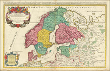
Blaeu's map of Scandinavia, baed upon Anders Bure's highly important map, published in 1626. A surveyor and mathematician, Bure compiled an important map of the northern part of Sweden and the first separately printed map of the country. Bure was an important figure in the history of Swedish cartography and set up a land surveying office which continued for over 200 years. Nice full color example, with sailing ships and decorative catrouche and 3 coat of arms. German text on verso.
Willem Janszoon Blaeu (1571-1638) was a prominent Dutch geographer and publisher. Born the son of a herring merchant, Blaeu chose not fish but mathematics and astronomy for his focus. He studied with the famous Danish astronomer Tycho Brahe, with whom he honed his instrument and globe making skills. Blaeu set up shop in Amsterdam, where he sold instruments and globes, published maps, and edited the works of intellectuals like Descartes and Hugo Grotius. In 1635, he released his atlas, Theatrum Orbis Terrarum, sive, Atlas novus.
Willem died in 1638. He had two sons, Cornelis (1610-1648) and Joan (1596-1673). Joan trained as a lawyer, but joined his father’s business rather than practice. After his father’s death, the brothers took over their father’s shop and Joan took on his work as hydrographer to the Dutch East India Company. Later in life, Joan would modify and greatly expand his father’s Atlas novus, eventually releasing his masterpiece, the Atlas maior, between 1662 and 1672.

![[Spitzbergen & Wiches Lande]](https://storage.googleapis.com/raremaps/img/small/61990.jpg)
![Chart of the North and Baltic Seas [insets of St. Petersburg, Heligoland and Revel]](https://storage.googleapis.com/raremaps/img/small/72115.jpg)