|
||

|

|
|

|
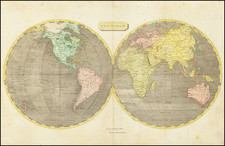
Striking example of Blaeu's maps of the World and continents.
Blaeu's set of the World & Continents are perhaps the most decorative and cartographically accurate of all sets published in the 17th Century. Blaeu's work set the standard for other map makers during the Golden Age of Cartography, characterized by fine engraving, high quality paper and fine geographical detail.
Blaeu's map of the world is one of the earliest maps to utilize the Mercator Projection, which allowed mariners in the open sea to make practical use of maps. Although the technique was not perfected for another 2 centuries, Blaeu's adoption of the standard was among the most significant milestones for the general acceptance of Mercator's work and one of the earliest broad disseminations. The map of the World is embellished with allegorical representations of the 4 seasons and 4 elements in the side panels, the 7 wonders of the Ancient World at the bottom and representations of the Classical Planets, moon and sun at the top. The World map's cartography features a fascinating depiction of the Northwest Coast of California, although it is noteworthy that Blaeu was one of the few commercial mapmakers to reject the myth of California as an island.
The details in North America reflect the activity of the Enlish and French in their colonies in Virginia, Canada and Florida, as well as the Dutch interest in a passage from the Atlantic to the Pacific Oceans to further Dutch trading interests, hence the inclusion of recent discoveries by Hudson, Davis and others. The map also includes a grande Terra Australis Incognita, which even retains some of the mythical geography of Marco Polo. The maps of the 4 continents are embellished with depictions of the major cities of each continent atop the maps and a depiction of the costumes of various indigenous people along the side panels. A generally fine example of this highly decorative set. Minor repaired fold split in the World map just entering the printed image, else nice wide margined examples of each of the maps, with German text on the verso.
Willem Janszoon Blaeu (1571-1638) was a prominent Dutch geographer and publisher. Born the son of a herring merchant, Blaeu chose not fish but mathematics and astronomy for his focus. He studied with the famous Danish astronomer Tycho Brahe, with whom he honed his instrument and globe making skills. Blaeu set up shop in Amsterdam, where he sold instruments and globes, published maps, and edited the works of intellectuals like Descartes and Hugo Grotius. In 1635, he released his atlas, Theatrum Orbis Terrarum, sive, Atlas novus.
Willem died in 1638. He had two sons, Cornelis (1610-1648) and Joan (1596-1673). Joan trained as a lawyer, but joined his father’s business rather than practice. After his father’s death, the brothers took over their father’s shop and Joan took on his work as hydrographer to the Dutch East India Company. Later in life, Joan would modify and greatly expand his father’s Atlas novus, eventually releasing his masterpiece, the Atlas maior, between 1662 and 1672.
![[Early Photographic Facsimile of the Rosselli-Sonetti Woodblock World Map] Figura & Scrittura in soma di tutti lo habitato](https://storage.googleapis.com/raremaps/img/small/66515.jpg)
![[Pictorial World Map Gameboard]](https://storage.googleapis.com/raremaps/img/small/88775.jpg)