The item illustrated and described below is sold, but we
have another example in stock. To view the example which
is currently being offered for sale, click the
"View Details" button below.
![[Shows Republic of Texas] United States and Texas By Alexander Keith Johnston](https://storage.googleapis.com/raremaps/img/small/101139.jpg)


|
||

|

|
|

|
Stock# 14930
Description
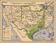
A large and detailed map of the United States, featuring Texas in a large configuration shortly after its admission to the Union. Kanzas Territory appears, immediately below a massive Nebraska Territory (which extends to Canada) . Excellent detail in Texas, including many Indian Villages, roads and towns. Also shows a large early Minnesota Territory and part of New Mexico. Bent Fort, Gant Fort and Chienne are shown on the Arkansas River. While the earlier states of this map showing Texas as a Republic are more readily available, this late state with Kanzas Territory rarly appears on the market.

![Charte von Den Vereinigten Staaten von Nord-America nebst Louisiana . . . 1805 [Rare 1st State of Gussefeld's Louisiana Purchase Map]](https://storage.googleapis.com/raremaps/img/small/63496.jpg)