This item has been sold, but you can enter your email address to be notified if another example becomes available.


|
||

|

|
|

|
Stock# 14730
Description
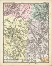
A fine example of HH Lloyd's scarce double page map of this portion of the Transmississippi West, centered on the Rocky Mountains. Tremendous detail throughout, too much early information to describe in detail. Includes counties, towns, railroads, mountains, rivers, explorer routes, US Mail Route, Indian lands and a host of other details. HH Lloyd never did issue his Atlas of the United States, but portion appeared in Warner & Beers Atlases during the 1870s. This map was only included in the earliest editions of the work. Minor fold soiling and a few maringal tears, but still a nice example. This map normally appears dated 1872 and later. 1869 examples of this map are very rare.
![Map of Oregon Territory. By Samuel Parker. 1838. [with:] Journal of an Exploring Tour Beyond the Rocky Mountains, under the direction of the A. B. C. F. M. 1840.](https://storage.googleapis.com/raremaps/img/small/97939.jpg)

![[First Map of the Mississippi River] Carte de la decouverte faite l'an dans l'Amerique Septentrionale](https://storage.googleapis.com/raremaps/img/small/93571.jpg)
![Mexique par Th. Duvotenay…1842 [Republic of Texas]](https://storage.googleapis.com/raremaps/img/small/93713.jpg)