


|
||

|

|
|

|
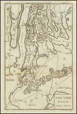
Detailed Map of the region around Manhattan and New York City, including Brookland (Brooklyn), Flatbush, Gravesend, New Utrecht, Gowen's Cover, Flatland, Flushing, New Town, Whiston, West Chester, Frogs Neck, East Chester, Bloomingdale, King's Bridge, Fort Independence, Spiking Devil, Jeffery Hook, Cheveaux de Friese, Fort Washington, Haerlem, Morrisania, Turtle Bay, Kep's Bay, Robt Murray's House Bergen, Brookland Ferry, Red Hook, Hobock, Redubt and Bushwick Inlet, Horen's Brook, Dykeman's Bridge and other place names. Several Battle Plan details, including the March of the Troops under Gen'l Clinton, the Road to Jamaica, the point where Gen'l Grant engaged Ld. Stirling, etc. Numerous roads are also shown. A fine example, in attractive color. The map appeared in Dr. Gordon's History of the American War, one of the best contemporary British Accounts of the Revolution.
![[New England] Tierra Nueva](https://storage.googleapis.com/raremaps/img/small/64626.jpg)
![(Three Days at Gettysburg) Map of the Battlefield of Gettysburg July 1st, 2nd, 3rd 1863. . . [Three Maps]](https://storage.googleapis.com/raremaps/img/small/101769.jpg)