|
||

|

|
|

|
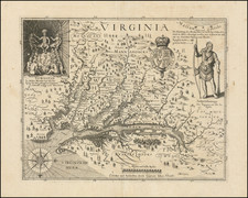
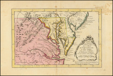
Nice example of one of the earliest obtainable maps of Virginia published in the U.S. Shows counties, towns, roads, rivers, lakes, islands, harbors, bays, court houses, along with topographical details. Based upon Benjamin Tanner's map, which appeared in the Reid Atlas. Wheat & Brun 574. This map appeared in Volume IV of John Payne's New and Complete Universal Geography… published in New York by John Low at the Shakespeare Head, No. 332 Water-Street, in 1799. Following the publication of Carey's American Atlas in 1795, there were a small group of 18th Century works which included a complete set of state maps, including John Reid's American Atlas, Joseph T. Scott's Gazetteer, Carey's Pocket atlas and works by Jeddidiah Morse. This small group of maps and the few separately issued maps of the region, which are now virtually unobtainable, mark the beginnings of the indigenous cartographic publishing business in America, and are now highly soughtafter. From the first edition of Reid's American Atlas, the second folio atlas published in America. Wheat & Brun 572. An important 18th Century American imprint for Viriginia collectors.
Following Mathew Carey’s publication of the American Atlas in 1795, the second large format atlas published in America was produced by John Reid of New York in 1796. The project began as an atlas to accompany William Winterbotham’s An Historical, Geographical, Commercial and Philosophical View of the United States, but was also sold separately under the title The American Atlas.
Reid’s atlas included 20 maps. In addition, John Russell’s plan of Washington, D.C. is also bound into some copies of the Atlas. Reid’s atlas was a collaborative work, with 9 of the maps engraved by Benjamin Tanner, 5 by David Martin, two by D. Anderson and one each by John Scoles and John Roberts. Two of the maps do not include engraving credits. Each of the engravers was probably working in New York (including Tanner, who had not yet relocated to Philadelphia). According to the various entries for the maps in Wheat & Brun, the cartographic content of the maps is drawn largely from Carey’s first atlas of 1795.
![[ Carolinas & Georgia ] Carte De La Caroline Et Georgie . . .](https://storage.googleapis.com/raremaps/img/small/99744.jpg)