


|
||

|

|
|

|
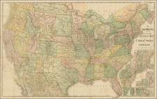
Rare double page map of the United States, showing early territorial boundaries throughout the Transmississippi West. Nebraska extends to the Rocky Mountains and Canada. Oregon & Washington extend from Nebraska to the Pacific. Massive Kansas, extending from Missouri to the Rocky Mountains. New Mexico and Utah run from California to (and beyond) the Rocky Mountains. Massive Texas includes all of Indian Territory. Perhaps the most notable of all features is the ephemeral naming of Arizona or Gadsden in the area south of the Gila River. This is the area between the line created by the Treaty of Guadalupe Hidalgo and the Gadsden Purchase, which resulted in the inclusion of Tuscon and Phoenix within what is now the U.S. This is one of only two or three maps we have ever seen which formally names Arizona as Gadsden. Very rare. Only the 2nd time we have had the map in 15 years.

![[United States] Index Map](https://storage.googleapis.com/raremaps/img/small/67626.jpg)