The item illustrated and described below is sold, but we
have another example in stock. To view the example which
is currently being offered for sale, click the
"View Details" button below.


|
||

|

|
|

|
Stock# 14462
Description
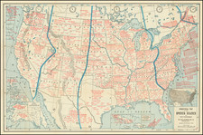
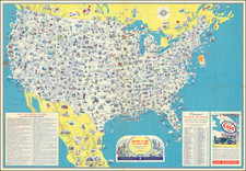
A gorgeous example of Flemming's 4 sheet map of the United States, exhibiting in fabulous detail the early US territorial borders, Indian Districts, Forts, early routes of the Transmississippi explorers and other details. Includes the various European colonies in Texas, many Indian tribes, forts, missions, roads, and other details. Too much good material to mention. Includes a very unusual tomahawk shaped Indian Territory and massive Minnesotah and Missouri Territories. Excellent topographical details, some real, some conjecture. One of the great pre-Gadsden Purchase atlas maps. Expertly joined on linen. Not in Wheat.
![A Map of Lewis and Clark's Track Across the Western Portion of North America, from the Mississippi to the Pacific Ocean. By Order of the Executive of the United States in 1804, 5 & 6. . . . [Complete with 3 volumes of Text: Travels to the Source of the Missouri River and Across the American Continent to the Pacific Ocean. Performed by Order of the Government of the United States, in the Years 1804, 1805, and 1806].](https://storage.googleapis.com/raremaps/img/small/81775.jpg)