This item has been sold, but you can enter your email address to be notified if another example becomes available.


|
||

|

|
|

|
Stock# 14455
Description
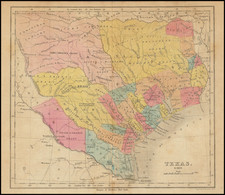
One of the great early territorial maps of the Southwest from Carl Flemming's atlas. Includes excellent topographical details, towns, forts, rivers, mountains, and many Indian names. Fascinating early borders for Texas and Utah. Names many Indian Tribes, forts, etc. Texas is shown as a republic. Demonstrates the marvelous engraving style of mid-19th Century German publishers. Minor waterstains top and bottom, the latter just entering the image, but a nice example.

![(Humboldt Atlas and Text) Geographique et Physique du Royaume de Nouvelle-Espagne [with quarto text:] Essai Politique de la Royaume de la Nouvelle-Espagne](https://storage.googleapis.com/raremaps/img/small/99796.jpg)