|
||

|

|
|

|
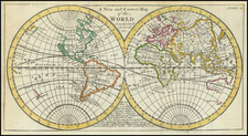
Extremely rare map of the World, illustrating the tracks of Krusenstern's three year voyage around the World.
The map appeared in the Atlas Ptueshestviiu Vokrug Sviets Kapitana Kruzenshsterna, which accompanied Krusenstern's Poutechestvie vokroug sveta. . . . 1803-1806, the first edition of the official account of the first Russian expedition to circumnavigate the globe, under the command of Ivan F. von Krusenstern, between 1803 and 1806.
This famous expedition under the command of Capt. Krusenstern, by Order of His Imperial Russian Majesty, Alexander I, sailed from Kronstadt on the 7th of August, 1803, and after touching at Falmouth, the Canaries and Brazil, then rounded Cape Horn, visiting the Marquesas Islands, Hawaii, Kamchatka, and Japan. In Hawaii the expedition separated, with ships under Langsdorff and Lisianski sailing to the Northwest Coast, while Krusenstern himself undertook an expedition to Japan, with the goal of opening Russian relations with that country. He then returned via Macao and the Cape of Good Hope.
The voyage was one of the most important post-Cook Pacific voyages, specifically aimed at obtaining more knowledge of the northern Pacific region, establishing diplomatic and commercial relations with Japan, and visiting the Russian trading posts in Alaska and on the west coast of America. The work was first published in Russian in 3 volumes and folio atlas in St. Petersbourg, 1809--13, and later republished in German at St. Petersbourg 1810--12 in 3 vols., accompained by a folio atlas in 2 volumes, one consisting of 39 Charts and the other of 69 Views, Natural History Plates and Natives. These folio Atlases are of excessive rarity and most frequently imperfect.
This first edition is listed, though unlocated by Sabin. It was unknown to Bancroft, and is unrecorded by Smith, Cox, Golder, et al. An extreme rarity. The last complete edition of the work was offered by Eberstadt in his catalogue 119 (item #123) in 1950 ($500.00).
There is no record of the World Map or the Atlas being offered at auction or in a dealer catalogue in the past 50 years. A second edition of the atlas (1824--18 maps only) was offered in Martayan Lan Catalogue #23.
Ex-Chicago Historical Society, with pencil markings in the lower left and right corners and an note -- Early American Maps No. 67 -- about the title. Old fold split reinforced on verso.
Ivan Fedorovich Krusenshtern, also known as Adam Johann von Krusenstern (1770-1846) was a Russian naval officer and hydrographer. He led Russia’s first circumnavigation and published numerous charts, particularly of the Pacific Ocean region.
Krusenstern was born in Hagudi, then part of the Russian Empire but now in Estonia. At the age of seventeen he joined the Russian Imperial Navy and first saw action in a conflict with Sweden. He was seconded to the British Royal Navy during the Napoleonic Wars. Between 1793 and 1799 he served in British vessels and traveled to North America, China, South Africa, and beyond. He then returned to Russian service and lobbied the Imperial Navy to support a voyage of exploration that would also serve as Russia’s first circumnavigation.
Under the patronage of Alexander, Count Nikolay Petrovich Rumyantsev and the Russian-American Company, Krusenstern led the first Russian circumnavigation of the world from 1803 to 1806. This mission was aimed at enhancing the fur trade with Russian America, notably Alaska, and sought to establish trade relations with China and Japan, explore trade possibilities in South America, and survey the coast of California for potential Russian settlement.
The expedition consisted of two ships: the Nadezhda (formerly the British Leander), commanded by Krusenstern, and the Neva (previously the British Thames), under Captain-Lieutenant Yuri F. Lisianski. Departing from Kronstadt in August 1803, the voyage spanned the globe, passing Cape Horn, exploring the northern Pacific, and returning via the Cape of Good Hope, with Krusenstern arriving back in Kronstadt in August 1806. The expedition made important contributions to oceanography and hydrography in the Marquesas, Japan, Sakhalin, and the Northwest Coast of North America. Upon his return, Krusenstern was celebrated as a pioneer of Russian science and was awarded an honorary membership in the Russian Academy of Sciences. He would later also be named a foreign member of the Royal Swedish Academy of Sciences and the Royal Society of London.
Following the expedition, Krusenstern documented the journey in a comprehensive report titled "Reise um die Welt in den Jahren 1803, 1804, 1805 und 1806 auf Befehl Seiner Kaiserlichen Majestät Alexanders des Ersten auf den Schiffen Nadeschda und Newa," first published in Saint Petersburg in 1810. This report was later translated into multiple languages and published in various European cities. Krusenstern's contributions to geographic knowledge were further highlighted in his 1827 publication of an atlas of the Pacific.
His geographical findings and contributions to the field brought him recognition, including honorary membership in the Russian Academy of Sciences and foreign memberships in the Royal Swedish Academy of Sciences and the American Philosophical Society.
Krusenstern devoted the rest of his life to improving the Russian Imperial Navy and navigation. For the first years after his return he devoted himself to writing a voyage account and compiling an atlas of his voyage. Then, he acquired new instruments for the Imperial Navy on a trip to London in 1814 and 1815. He served as director of the Imperial Naval Academy from 1824 to 1842.
He continued to publish throughout his life. As part of his ongoing project to make Russia’s navy one of the best in Europe, he often looked to others for examples. He was an admirer of the Royal Navy and corresponded with many officers, but he also appreciated the Spanish Navy and its Hydrographic Service. He published several articles about the Malaspina expedition, for example, in 1815 and 1824-7.
Krusenstern also played a significant role in naval education as the director of the Russian naval school and was involved in the scientific committee of the marine department. His work in improving maritime navigation, specifically in developing a method to reduce the impact of a ship's iron on compass readings, was adopted in the navy. He was promoted to admiral in 1841 and received the Pour le Mérite in 1842.
His most notable publication is his Reise um die Welt, in den jahren 1803, 1804, 1805, und 1806, published from 1810-12 in three volumes with an atlas. In 1824, he published his famous Atlas de l’Ocean Pacifique, the most complete hydrographic representation of the Pacific Ocean region to date.

![[Early Photographic Facsimile in 24-Sheet of the Verrazano World Map]](https://storage.googleapis.com/raremaps/img/small/67041.jpg)