|
||

|

|
|

|
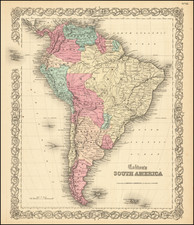
A Rarity Meant to Guide Sailors through the South Atlantic
Very rare sea chart of the southern Atlantic Ocean, South America and the West Coast of Africa, issued by William Herbert in London.
The general chart was issued separately and also included in William Herbert's influential A New Directory for the East Indies, issued from ca. 1740 to 1790. It was based on a previous chart by John Senex.
Drawn on the Mercator projection, the chart is riddled with rhumb lines, the better to plot a course with. Although primarily meant as a navigational chart, albeit at a low resolution, the interiors of the landmasses are also detailed. South America is riddled with rivers. Africa, by contrast, contains only details close the coastline.
There are two unfinished coastlines on islands in the South Atlantic. Farther west, near the eastern entrance to the Strait of Magellan, are parts of the Falklands and the tiny dots of the Sebald de Weerts. The Sebalds or Sebaldines were charted by Sebald de Weert, a Dutchman, as he fled from the treacherous Strait at the turn of the seventeenth century. Nearly a century later, in 1690, John Strong sailed amongst nearby (or the same) islands and called them the Falklands.
To the east is “Cape Circumcision discovered 1739.” The island was discovered on January 1, 1739, the first time that land had been spotted south of the 50th parallel south. Bouvet de Lozier saw the island through the fog. He was not able to land, and did not circumnavigate his discovery, thus not clarifying if it was an island or part of a continent. This obscurity and potential made it of intense interest to geographers.
Herbert's chart was intended for use by officers aboard East Indiamen and Royal Navy vessels sailing for Australia, and the trading ports of India, Southeast Asia, and China. Some might have been intended for Cape Horn, but very few voyages ventured in that direction before the 1760s.
These navigators and officers made up a niche market at the time, but their work was of the utmost importance to the British Empire and global commerce more generally. These charts were therefore highly prized by their users and heavily used at sea and in other trying environments. As a result, very few examples of the charts and even fewer examples of the complete Directory have survived.
Rarity
The map is extremely rare. This is only the second example we have offered for sale since 1992.
The English mapmaker William Herbert (1718-95) traveled to India in about 1748 as a purser's clerk. Herbert's cartographic publishing started to take form in the late 1740s, when he set up a map and print shop on London Bridge. In 1758, with the encouragement of the East India Company, he introduced a new pilot guide, A New Directory for the East Indies. Herbert gathered superior sources than those used in Mount & Page's The Third Book, consulting such works as Mannevillette's Neptune Oriental, as well as the navigator William Nicholson and the cartographer Samuel Dunn. He often worked with colleagues, including Jefferys, Sayers, Dury, and Andrews, and is recorded as a seller of the famous Anti-Gallican map. In 1776 he retired, having apparently made a fortune. His business was carried on by Henry Gregory Sr.