|
||

|

|
|

|
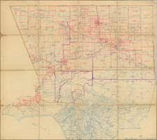
Fascinating set of 4 separately issued maps, from one of France's leading map makers. While the maps appear individually and in bound atlases, this is a rare set, almost certain assembled on request by the mapmaker for a contemporary client.
The maps include:
(1) Carte Generale des Etats-Unis Mexicains et des Provinces-Unies De L'Amerique Centrale ,,, Marvelous map of Mexico and the Southwest, coming shortly after Mexico's Independence from Spain. Excellent pre-Smith cartography in Upper or New California, including the 3 rivers feeding the two Great Salt Lakes in Utah. Nice post Humboldt-Pike-Long cartography through the Rocky Mountains and the Plains. Excellent detail in Texas, which is named, without sign of the Austin, who was just then establishing first contacts with the region after obtaining a grant from Mexico in January 1823. Wheat notes that the reference on the Rio Sacramento's navigability to 50 liguas is one of the earliest observations on the Sacremento River.
(2) Carte Generale des Etats Unis De L'Amerique Septentionale... An early example of the United States mapped coast to coast. The map is especially interesting west of the Mississippi, where it shows a double wide Arkansa Territory, Oregon Territory extending from the Mississippi to the Paicfic, early regional reference to Texas, two Salt Lakes w/two rivers flowing to the Pacific, fabulous detail in the Pacific Northwest relying upon Lewis & Clark and the Hudson's Bay Co writings, etc. The map is one of the most detailed renderings of the drainage systems of the Rockies and Upper Mississippi prior to Nicollet. Several early forts are shown in Texas. The Missions and early mythical rivers shown in California.
(3) Carte Particuliere des Iles Antilles ou des Indes Occidentales. . . . Highly detailed chart of the Gulf of Mexico from Florida and the Bahamas to Mexico, the Yucatan, Central America & the northern tip of South America (Venezuela). Includes the Caribbean Sea and the West Indies islands with a table in lower left indicating country of ownership for each major island under Spain, France, England, Denmark, Holland and Sweden.
(4) Carte Generale de L'Amerique Meridionale et des Iles Qui en Dependent. Carte Generale des Etats-Unis de L'Amerique Septentrionale. Early map of South America, during the century of revolution.
Andre Hubert Brué was a French geographer and cartographer. Born in Paris, he served in the French Navy, joining the Baudin expedition to the Pacific (1800-1804). After his sea service, Brué applied his navigation and charting skills to creating finely-crafted maps, which were renowned for their crisp engraving and accuracy. He drew directly on the copper of the plate, creating what he called encyprotypes. He is best known for the Atlas universal de géographie physique, politique, ancienne et moderne.
![[ Colorado Atlas -- Presentation Copy ] Geological and Geographical Atlas of Colorado and Portions of Adjacent Territory](https://storage.googleapis.com/raremaps/img/small/101702.jpg)
![[Texas & Oklahoma] Amer. Sep. No. 55. Partie Des Etats-Unis](https://storage.googleapis.com/raremaps/img/small/93537.jpg)