|
||

|

|
|

|
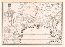
Fine example of Rigobert Bonne's map of Florida, Louisiana and the Mississippi Valley during the American Revolutionary War. The map provides an excellent look at the region shortly before it would become the object of Thomas Jefferson's desires, resulting in the Louisiana Purchase. Florida is depicted in a very primitive fashion, with the St. Johns River draining a series of Lakes in the interior of the southern part of Floria, with only a few early place names. Nice detail in Alabama & Mississippi, including numerous Indian Tribes, Villages and a few early settlements, including Ft. Mobile, Biloxi, Ft. Louis, Apalachiola, Apalaches, Fort Crevecoeur, etc. Excellent detail along the Mississippi River, from New Orleans to the confluence of the Missouri and Illinois Rivers, including a number of Indian Villages, the Ancient fort at the confluence of the Ohio, Fort Prudhomme, Fort Natchez, Fort Pierre and Ft. de la Point Coupee. Nice detailon either side of the Appalachians as well. A fascinating map, at a critical time in American history.
Rigobert Bonne (1727-1794) was an influential French cartographer of the late-eighteenth century. Born in the Lorraine region of France, Bonne came to Paris to study and practice cartography. He was a skilled cartographer and hydrographer and succeeded Jacques Nicolas Bellin as Royal Hydrographer at the Depot de la Marine in 1773. He published many charts for the Depot, including some of those for the Atlas Maritime of 1762. In addition to his work at the Depot, he is best known for his work on the maps of the Atlas Encyclopedique (1788) which he did with Nicholas Desmarest. He also made the maps for the Abbe Raynals’ famous Atlas de Toutes Les Parties Connues du Globe Terrestre (1780).
More than his individual works, Bonne is also important for the history of cartography because of the larger trends exemplified by his work. In Bonne’s maps, it is possible to see the decisive shift from the elaborate decorations of the seventeenth century and the less ornate, yet still prominent embellishments of the early to mid-eighteenth century. By contrast, Bonne’s work was simple, unadorned, and practical. This aesthetic shift, and the detail and precision of his geography, make Bonne an important figure in mapping history.

![[Eastern Sheet -- Ohio] Post Road Map of the States of Ohio and Indiana with Adjacent Parts of Pennsylvania Michigan Illinois Kentucky and West Virginia Showing Post Offices With The Intermediate Distances and Mail Routes In Operation On the !st of February 1885 . . .](https://storage.googleapis.com/raremaps/img/small/44153.jpg)
![[ Pictish Man Holding Severed Head ] Picti icon](https://storage.googleapis.com/raremaps/img/small/99837.jpg)