


|
||

|

|
|

|
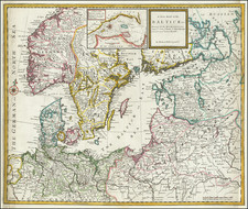
Striking full color example of Ottens map of Denmark and the southern parts of Sweden and Norway, based upon an earlier map by Frederick De Wit. Centered on Copenhagen and Lund. Extens to Hamburg, Wismar, Rostock and Wolgast. Ornate cartouche with coat of arms. A striking example of this scarce map.
The Ottens brothers, Reiner and Joshua, operated a successful printing partnership in the mid-eighteenth century (fl. 1726-1765). They began the venture in 1726, publishing maps and other prints as “R & I Ottens.” They specialized in the reprinting of others’ work, especially Guillaume De L’Isle. In 1750, Reiner died; his soon, also Reiner, took his place, but the firm began listing their works as “Joshua & Reiner Ottens.” The firm lasted until Joshua’s death in 1765. Joshua’s widow, Johanna de Lindt, sold their remaining stock of plates in 1784.
![Europae Tabula VIII [Russia, Ukraine, Baltic, Scandinavia]](https://storage.googleapis.com/raremaps/img/small/86526.jpg)