|
||

|

|
|

|
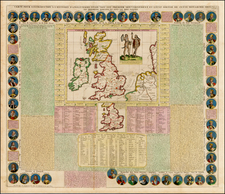
Third state of De Ram's rare map of England, updated and corrected by Reiner & Josua Ottens.
Includes a massive Alphabetical Table of the Cities and Market-Townes on the great roads in England and Wales, Their Latitude and Longitude and in what County they are Lying . . . Ornate cartouche and rich full color.
The Ottens brothers, Reiner and Joshua, operated a successful printing partnership in the mid-eighteenth century (fl. 1726-1765). They began the venture in 1726, publishing maps and other prints as “R & I Ottens.” They specialized in the reprinting of others’ work, especially Guillaume De L’Isle. In 1750, Reiner died; his soon, also Reiner, took his place, but the firm began listing their works as “Joshua & Reiner Ottens.” The firm lasted until Joshua’s death in 1765. Joshua’s widow, Johanna de Lindt, sold their remaining stock of plates in 1784.
![[ Pictish Man Holding Severed Head ] Picti icon](https://storage.googleapis.com/raremaps/img/small/99837.jpg)