|
||

|

|
|

|
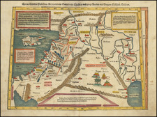
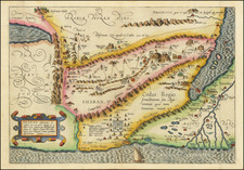
Goregous example of Ottens map of the Holy Land, oriented to the West, and divided among the Tribes of Israel on both sides of the Jordan. The shore line runds from Sidon to Egypt. The Kishon River connects Haifa Bay to the Lake of Tiberias. Along the top, a garland is supported by 6 cherubs. At the bottom center, the encampment of the Tribes in the desert surrounding the Tabernacle, flanked by Moses and Aaron. The map is drawn from Visscher's map of 1659, with minor changes. Richly embellished and highly detailed.
The Ottens brothers, Reiner and Joshua, operated a successful printing partnership in the mid-eighteenth century (fl. 1726-1765). They began the venture in 1726, publishing maps and other prints as “R & I Ottens.” They specialized in the reprinting of others’ work, especially Guillaume De L’Isle. In 1750, Reiner died; his soon, also Reiner, took his place, but the firm began listing their works as “Joshua & Reiner Ottens.” The firm lasted until Joshua’s death in 1765. Joshua’s widow, Johanna de Lindt, sold their remaining stock of plates in 1784.